

Altamimi, Z., Rebischung, P., metivier, L., Collilieux, X. (2016): ITRF2014: A new release of the International Terrestrial Reference Frame modeling nonlinear station motions // Journal of Geophysical Research – Solid Earth, 121 (8), doi: 10.1002/2016JB013098.
Altiner, Y., (2001): The contribution of GPS to the detection of the Earth's crust deformations illustrated by GPS campaigns in the Adria region // Geophys. J. Int. 145, pp. 550–559.
Battaglia, M., Murray, M.H., Serpelloni, E., Burgmann, R. (2004): The Adriatic region: An independent microplate within the Africa-Euroasia collision zone // Geophysical Research Letters, v. 31, doi:10.1029/2004GL019723.
Bennett, R. A., Hreinsdottir, S., Buble, G., Bašić, T., Bačić, Ž., Marjanović, M., Casale, G., Gendaszek, A., Coan, D. (2008), Eocene to present subduction of southern Adria mantle lithosphere beneath the Dinarides. Geology, 36(1), pp. 3–6.
Bakaert, D.P.S., Hooper, A., Wright, T. J (2015): Reassessing the 2006 Guerrero slow-slip event, Mexico, Implications for large earthquakes in the Guerrero Gap // Journal of Geophysical research: Solid Earth, 120, doi:10.1002/2014JB011557, pp. 1357-1375.
Cambell, j., Northnagel, A., (2000): Eurpean VLBI for crustal dynamics // Journal of Geodynamics, 30 (3), pp. 32-326.
D'Agostino, N., Avallone, A., Cheloni, D., D'Anastasio, E., Mantenuto, S., Selvaggi, G. (2008): Active tectonics of the Adriatic region from GPS and earthquake slip vectors // Journal of Geophysical Research, Vol. 113, B12413, doi:10.1029/2008JB005860.
Đapo, A. (2005): Obrada i intrepretacija geodetskih mjerenja na Geodinamičkoj mreži Grada Zagreba // Msc thesis, University of Zagreb, Faculty of Geodesy, Zagreb, Croatia.
Đapo, A., Pribicević, B., Medak, D., Prelogović, E. (2009): Correlation between Geodetic and Geological Models in the Geodynamic Network of the City of Zagreb // Reports on Geodesy, 86, pp 115-122.
Grenerczy, G., Sella, G., Stein, S., Kenyeres, A. (2005), Tectonic implications of the GPS velocity field in the northern Adriatic region. Geophys. Res. Lett. 32, L16311, doi:10.1029/2005GL022947.
Gourmelen, N., Amelung, F., Lanari, R. (2010): Interferometric synthetic aperture radar-GPS integration: Interseismic strain accumulation across the Hunter Mountain fault in the eastern California shear zone // Journal of Geophysical Research, vol 115, doi: 10.1029/2009JB007064.
Herak, D., Herak, M., Prelogović, E., Markusić, S., Markulin, Ž. (2005), Jabuka island (Central Adriatic Sea) earthquakes of 2003. Tectonophysics, 398, pp. 167–180.
Herak, M., Allegretti, I., Herak, D., Ivančić, I., Kuk, K., Marie, K., Markušić, S., Sović, I., (2011): Seismic hazard maps of Croatia // Geophysical Challenges of the 21st century Zagreb, (poster) Zagreb, Croatia.Herring, T., King, R., McClusky, S. (2006b): Documentation for the MIT GPS analysissoftware: GAMIT 10.3, Cambridge.
Herring, T. A., King, R. W., Floyd, M. A., McClusky, S. C. (2015b): GAMIT – GPS Analysis at MIT, Reference Manual 10.6, Department of Earth, Atmospheric and Planetary Sciences, Massachusetts Institute of Technology.
Hooper, A., Bekaert, D., Spaans, K., Arıkan, M.(2012): Recent advances in SAR interferometry time series analysis for measuring crustal deformation. Tectonophysics, 514, pp. 1–13.
Jordan, T. G., Minster, J. B. (1988): Beyond plate tectonics – Looking at plate deformation with space geodesy // The impact of VLBI on astrophysics and geophysics; Proceedings of the 129th IAU Symposium, Cambridge, MA, May 10-15, 1987 (A89-13726 03-90). Dordrecht, Kluwer Academic Publishers, pp. 341-350.
Kampes, B. M., Hanssen, R. F., Perski, Z. (2003): Radar interferometry with public domain tools. // In Third International Workshop on ERS SAR Interferometry, FRINGE03, Frascati, Italy.
Kastelic, V., Vannoli, P., Buratto, P., Fracassi, U., Tiberti, M.M., Valensise, G. (2013), Seismogenic sources in the Adriatic Domain. Marine and Petrol. Geol., 42, 191–213.
Kreemer, C., Blewitt, G., Klein, E. C. (2014): a geodetic plate motion and global strain rate model // Geochemistry, Geophysics, Geosystems, 15 (10), pp 3849-3889.
Massonnet, D., Feigl, K. L. (1998): Radar interferometry and its application to changes in the Earth's surface //Reviews of geophysics, 36 (4), pp 441-500.
Markušić, S., Herak, D., Ivančić, I., Sović, I., Herak, M., Prelogović, E. (1998), Seismicity of Croatia in the period 1993–1996 and the Ston–Slano earthquake of 1996, Geofizika, 15,83–102.
Mouratidis, A., Costantini, F. (2012): Ps and SBAS Interferometry over the broader area of Thessaloniki, Greece, using the 20-year archive of ERS and Envisat data // Proc. "Fringe 2011 Workshop", Frascati, Italy, 19-13.09.2011 (ESA SP-697, January 2012).
Sousa, J. J., Ruiz, A.M., Hooper, A. J., Hanssen, R.F., Perski, Z., Bastos, L.C., Gil, A.J., Galindo-Zaldivar, J., Sanz de Galdeano, C., Alfaro, P., Garridom M. S., Armenteros, J. A., Gimenez, E., Aviles, M. (2014): Multi-temporal InSAR for deformation monitoring of the Granada and Padul faults and the surrounding area (Beltic Cordillera, southern Spain) // Procedia Technology, 16, doi: 10.1016/j.protey.2014.10.040, pp 886-896.
Oldow, J., Ferranti, L., Lewis, D., Campbell, J., D'Argenio, B., Catalano, R., Pappone, G., Carmignani, L., Conyi, P., Aiken, C. (2002): Active fragmentation of Adria, the north African promontory, central Mediterranean orogeny // Geology, 28, pp 87-96.
Osmanoğlu, B., Sunar, F., Wdowinski, S., Cabral-Cano, E. (2016): Time series analysis of InSAR data: Methods and trends. ISPRS Journal of Photogrammetry and Remote Sensing, 115, 90–102.
Papazachos, B.C., Comninakis, P.E., Scordilis, E.M., Karakaisis, G.F., Papazachos, C.B. (2009), A Catalogue of Earthquakes in Mediterranean and Surrounding Area for the Period 1901–2008. Univ. of Thessaloniki, Thessaloniki, Greece. [http://geophysics.geo.auth.gr/ss/CATALOGS/seiscat.dat].
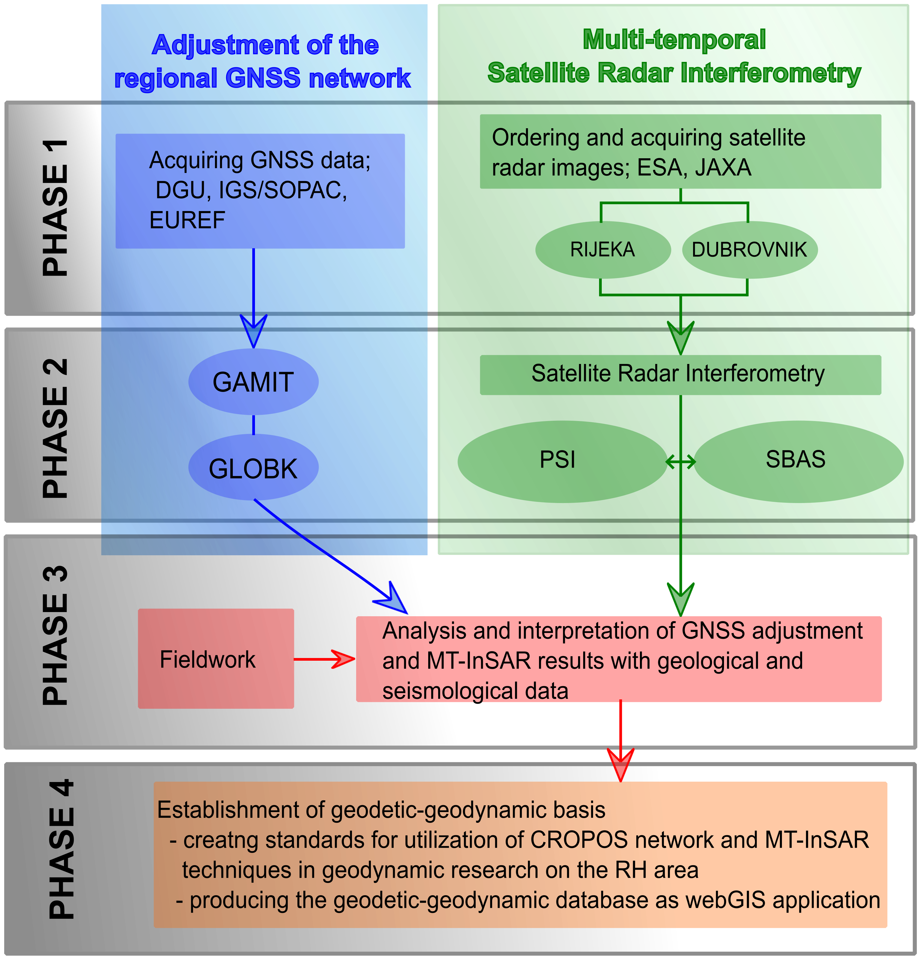
Pavasović, M. (2014): CROPOS kao Hrvatski terestrički referentni okvir i njegova primjena u geodinamičkim istraživanjima // Doktorska disertacija, Geodetski fakultet Sveučilišta u Zagrebu.
Pribičevic, B., Đapo, A., Medak, D. (2011): Geodetic-Geologic Research on Wider Zagreb area based on Geodynamic Network of the City of Zagreb // Geodetski list, 65(88), pp. 1-19.
Pribičević, B., Đapo, A., (2016): Movement Analysis on Geodynamic Network of the City of Zagreb from Different Time Epochs // Geodetski list, (0016-710X) 70(93), 3, pp. 207-230.
Pribičević, B., Đapo, A., Govorčin, M., (2017): The Application of Satellite Technology in the study of Geodynamic movements in the wider Zagreb area // Technical Gazette, Vol. 24. No. 2, pp 503-512.
Schmid, S.M., Bernoulli, D., Fugenschuh, B., Matenco, L., Schuster, R., Schefer, S., Tischler, M., Ustaszewski, K. (2008), The Alpine‐Carpathian Dinaridic orogenic system: Correlation and evolution of tectonic units. Swiss J. Geosci., 101, pp. 139–183.
Tari, V. (2002), Evolution of the Northern and Western Dinarides: a Tectonostratigraphic Approach. In: Stephan Mueller Special Publication Series, vol. 1, pp. 223–236.
Tari Kovačić, V. and Mrinjek, E. (1994), The Role of Palaeogene Clastics in the Tectonic Interpretation of Northern Dalmatia (Southern Croatia). Geologia Croatica, 47/1, pp. 127–138.
Tomljenović, B., Herak, M., Herak, D., Kralj, K., Prelogović, E., Bostjančić, I., and Matoš, B. (2009), Active tectonics, seismicity and seismogenic sources of the Adriatic coastal and offshore region of Croatia. In: Slejko, D., Rebez, A. (Eds.), 28 Convegno Nazionale, Riassunti Estesi delle Comunicazioni. Stella Arti Grafice, Trieste, pp. 133–136.
Weber, J., Vrabec, M., Pavlocčič-Prešeren, P., Dixon, T., Jiang, Y., Stopar, B. (2010): GPS-derived motion of the Adriatic microplate from Istria Peninsula and Po Plain sites, and geodynamic implications // Tectonophsics, 483, pp. 214-222.